Mt. Thalay Sagar Expedition

Days: 24D/23N
Altitude: 6904
Distance: 135
Grade: Difficult
Pick Up: Dehradun
Drop: Dehradun
Base Camp: Kedartal
Season: Autumn (Sep–Oct)
Stay: Guesthouse + Tents

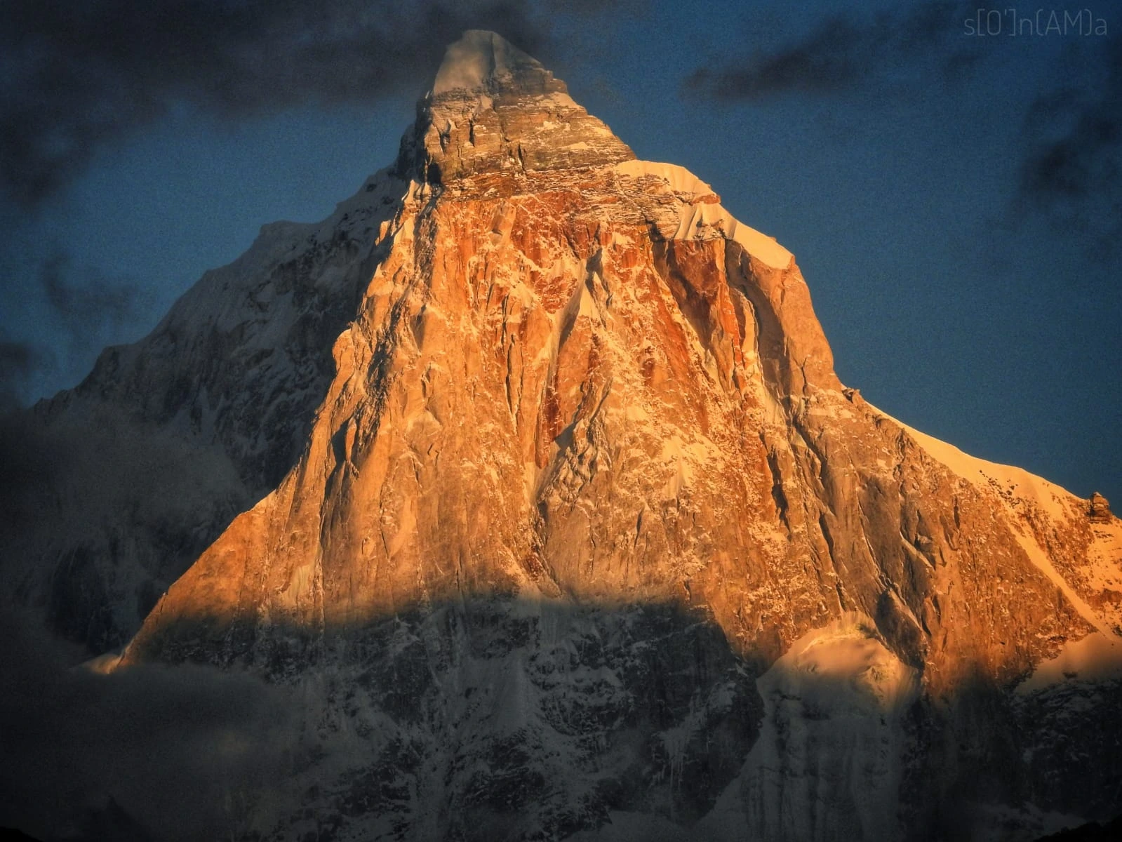
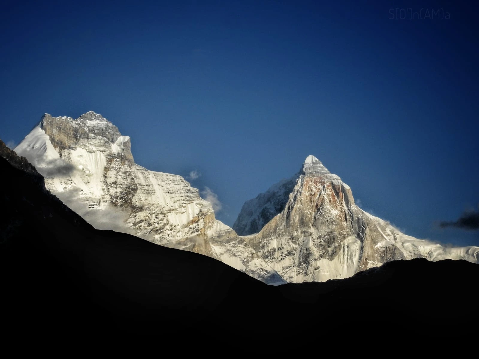
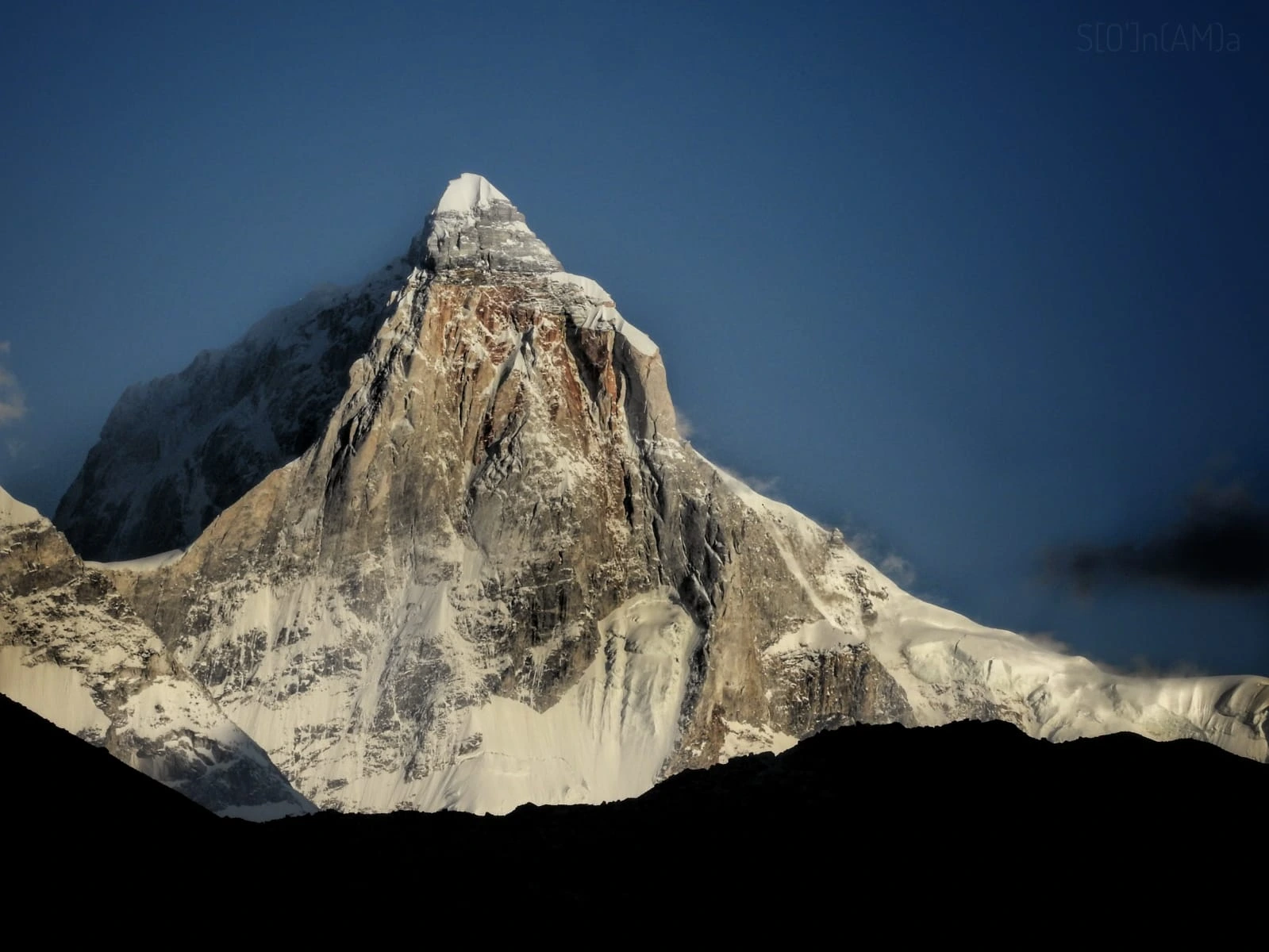
The Mt. Thalay Sagar Expedition (6,904 M) is one of the most technical and legendary mountaineering objectives in the Indian Himalayas. Rising sharply above the Gangotri region, Thalay Sagar is renowned for its steep faces, exposed ridgelines, and complex route conditions that demand high technical competence, sustained endurance, and disciplined decision-making.

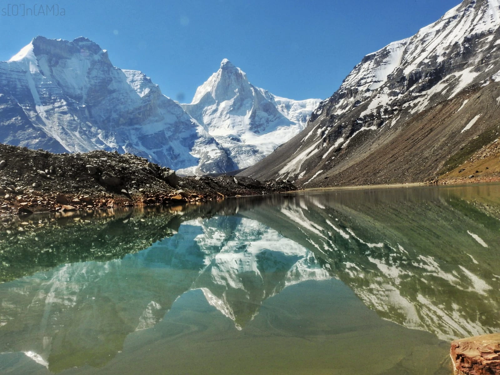
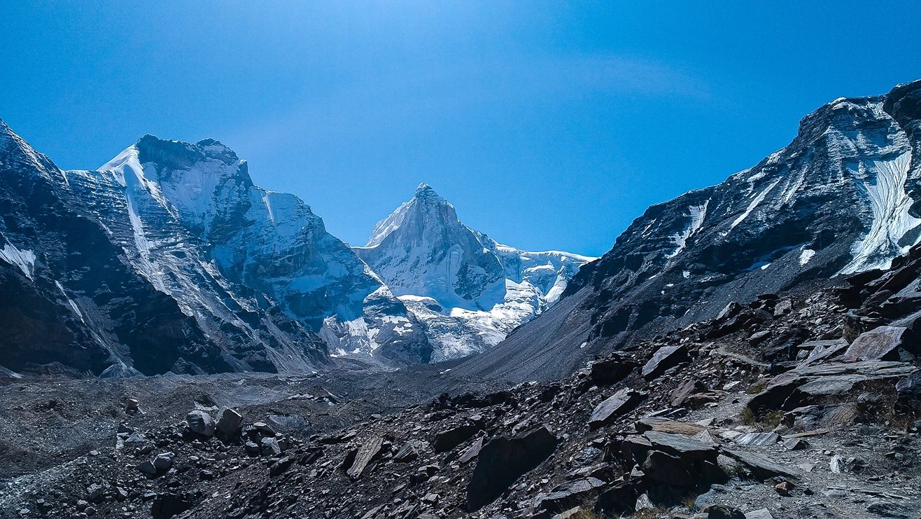
Although the summit altitude is below 7,000 meters, Thalay Sagar is often considered an elite climb because difficulty is driven more by terrain and exposure than by altitude alone. The expedition route begins from Gangotri and approaches the mountain through a demanding progression to Kedartal (Base Camp at 4,912 M)—a stunning high-altitude lake surrounded by rugged granite walls and snowfields.

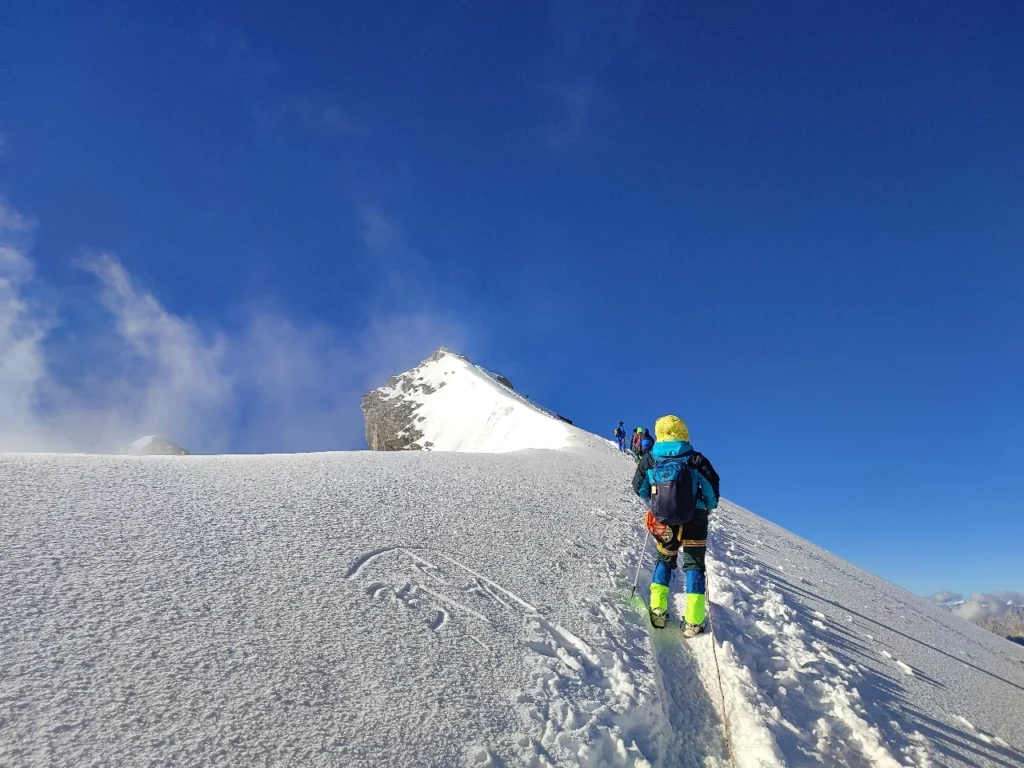
From Kedartal onward, the expedition enters a serious alpine phase involving multiple camps, repeated load ferries, rope fixing, and route opening by the technical support team. This structure is not optional; it is essential for:

  • Building safe acclimatization
  • Staging supplies at higher camps
  • Establishing fixed rope lines on technical sections
  • Creating a controlled summit push window

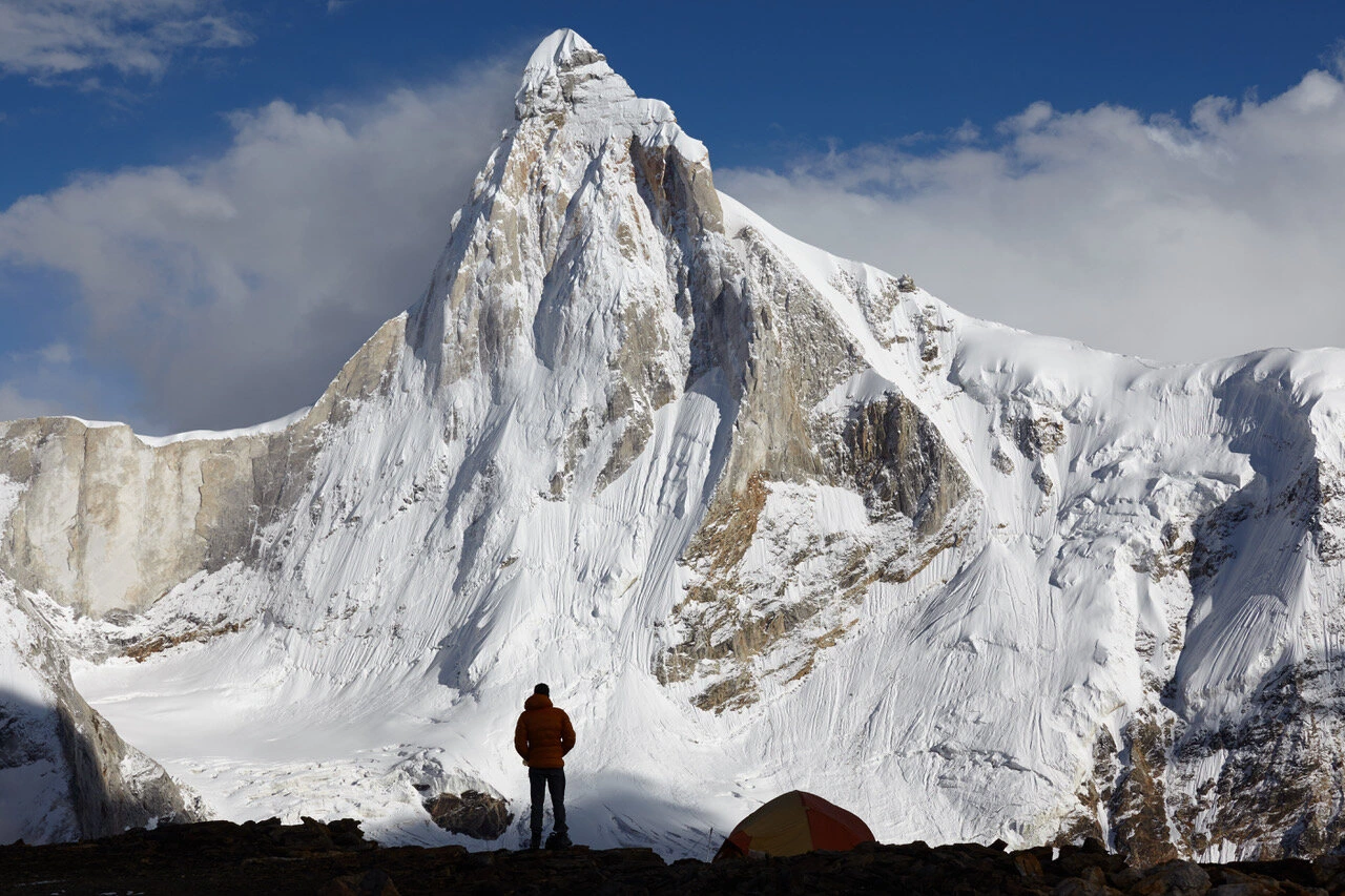
The climb requires advanced proficiency in snow and ice movement, fixed rope ascent/descent, and managing fatigue in exposed terrain above 6,000 meters. Summit attempts are strictly weather-dependent and executed only within safe, stable windows.

With Terranova Expedition, the Thalay Sagar climb is approached with conservative planning, methodical rotations, and safety-first leadership—ensuring that trekkers experience a professional expedition process on one of India’s most respected peaks.

HIGHLIGHTS OF THE MT. THALAY SAGAR EXPEDITION

  • One of the most technical major peaks in the Gangotri region
  • Remote approach through Bhuj Kharak, Kedar Kharak, and Kedartal
  • High-altitude base camp beside Kedartal lake
  • Multi-camp alpine expedition with route opening and rope fixing
  • Extended time above 6,000 meters (Camp III & Camp IV)
  • Elite mountaineering experience in Garhwal Himalayas
  • Powerful summit achievement with legendary Himalayan views

Itinerary

Day 1

Dehradun (636 M) to Gangotri (3,415 M)

Day 2

Rest & Acclimatization Day at Gangotri

Day 3

Gangotri to Bhuj Kharak (3,708 M)

Day 4

Bhuj Kharak to Kedar Kharak (4,270 M)

Day 5

Kedar Kharak to Kedartal (Base Camp – 4,912 M)

Day 6

Rest Day for Trekkers | Load Ferry by Sherpas (to ~5,030 M)

Day 7

Load Ferry to Camp I (Whole Team)

Day 8

Base Camp to Camp I (Occupy)

Day 9

Load Ferry to Camp II (5,335 M)

Day 10

Load Ferry to Camp II (5,335 M) Continues

Day 11

Rest Day at Camp I

Day 12

Camp I to Camp II (Occupy – 5,335 M)

Day 13

Route Opening to Camp III by Sherpa (6,000 M)

Day 14

Route Opening Continues to Camp III (6,000 M)

Day 15

Occupy Camp III (6,000 M)

Day 16

Camp III to Camp IV (Summit Camp – 6,400 M) Occupy

Day 17

Route Opening to the Summit

Day 18

Summit Attempt (6,904 M) & Return to Camp IV

Day 19

Reserve Day for Summit

Day 20

Reserve Day for Summit

Day 21

Return to Camp I

Day 22

Return to Base Camp (Kedartal)

Day 23

Return to Gangotri | Night Stay

Day 24

Drive Back to Dehradun | Expedition Closure

Inclusions & Exclusions

What’s included

  • Stay is included in Gangotri hotel/lodge on sharing basis.
  • You will be staying in high altitude tents during expedition on sharing basis.
  • Transportation from Dehradun to Gangotri and return.
  • Breakfast, lunch, dinner, snacks, soup, tea, hot drinks during expedition [Day 1 Dinner Day 23 Dinner]
  • High altitude meals.
  • Expedition permits & peak booking from Indian Mountaineering Foundation (For Indians)
  • Local National Park Permit Tourism department
  • Adventure Sports Cover & Medical Expense
  • Garbage cleaning charges.
  • Weather forecast report from the Indian Meteorological department & Windy.
  • Certificate of accomplishment
  • 3 men all season high altitude tents & high altitude tents, sleeping bag, mattress, kitchen tent, cutlery, dining & meeting tent & toilet tent, table & stool till base camp.
  • First aid, medical kit, oxygen cylinders, Blood pressure monitor, Oximeter, etc. will be available at all campsites to deal with emergencies.
  • Ice axe, snow boots, harness, carabiners, ascenders, descenders, gaiters, helmet, crampons, tape sling (all necessary safety & climbing gears)
  • Certified Expedition leader & Experienced Sherpas from Terranova Expedition.
  • Base Camp Manager
  • Cook, helper, mules support base camp.
  • High altitude cooks and supporting staffs for upper camp
  • Cloakroom facility for left luggage.

What’s not included

  • Mules or porters charge to carry personal luggage [Offload].
  • 5% GST
  • Any kind of personal expenses.
  • Expedition permits from Indian Mountaineering Foundation (For Foreigners)
  • Liaison Officer (For Foreigners)
  • Any early return travel costs or accommodation except for the days as per the itinerary.
  • Anything apart from inclusions.
  • Documentary filming, camera, and drone permit fee (if require)
  • Any emergency evacuation.
  • ASC 360 Insurance (Mandatory for Ladakh Region)
  • Tips for staffs


Refund & Cancellation

Quick Summary
Policy WindowRefund
30+ days before departure85%
20–29 days70%
15–19 days50%
7–14 days25%
< 7 days or no-showNo refund
If You Cancel
  • Advance/booking amount is non-refundable; reschedule credit may be offered if requested ≥ 7 days before departure.
  • Government permits, insurance, accommodation and transport already paid to vendors are non-refundable.
  • Force majeure (weather, landslides, strikes, roadblocks, government orders): trip may be postponed; paid amounts remain non-refundable; credit/reschedule may be offered where possible.
  • Unused services, early return or partial participation do not qualify for refunds.
  • Refunds are processed to the original payment method; allow 7–10 business days.
  • Name change/transfer possible until permits are issued; afterward, standard cancellation terms apply.

Things to Carry

Footwear

  • Waterproof Trekking Shoes [1 pair] Floaters / Slippers [1 pair] Socks [4-5 pair]

Clothing Layers

  • Quick dry T Shirts [3-4] Quick Dry Trek Pants [2] Windproof Pants for Sumit [1] Down Jacket [1] Thermal [1 set] Fleece [1] Windproof Jacket [1]

Rain Protection

  • Lightweight Rain Poncho Rain Jacket

Sun Protection

  • Sun Goggles UV Protected Sun Cap or Head Buff

Hydration

  • Water Bottle / Hydrapack [1L] Thermos Bottle [1L]

Snacks & Energy

  • Energy Bar Trail Mix Dry Fruits

Personal Medicines

  • Prescribed Medicines [If any] ORS

Headlamp & Batteries

  • Head Torch Spare Batteries Power bank Camera [If needed]

Warm Accessories

  • Woollen / Fleece gloves [1 pair] Waterproof Gloves [1 pair] Woollen / Fleece Beanie Neck Protector

Toiletries & Hygiene

  • Toiletery Kit [1 set] Quick Dry Towel [1] Toilet Paper Wet Wipes

Documents & Cash

  • Govt. ID Proof Emergency Cash Emergency Contact Number

Backpack & Daypack

  • 50-60L Rucksack [1] 20-30L Backpack [1]

How to Reach

By Air

  • Nearest airport: Jolly Grant Airport (Dehradun) – approx. 25 km from Dehradun
  • Direct flights available from Delhi, Mumbai & major cities

By Road

  • Delhi → Dehradun: 250 km
  • Overnight buses and taxis available

By Train

  • Nearest railway station: Dehradun Railway Station
  • Direct trains available from Delhi & major cities
FAQs

Common questions answered

How difficult is the Mt. Thalay Sagar Expedition?

Mt. Thalay Sagar is highly technical and considered one of the toughest major peaks in the Garhwal Himalayas.

Is Thalay Sagar a 7000-meter peak?

No, it is 6,904 meters, but it is technically extremely demanding.

What experience is required?

Trekkers should have successful 6000–6500 m expeditions and strong snow/ice climbing and rope skills.

Why are there multiple load ferry days?

They are essential for acclimatization, staging supplies safely, and building route familiarity before committing to higher camps.

How cold does it get near summit camp?

Temperatures can drop below –25°C to –30°C with wind chill.

What is the trekking distance of the expedition?

Total travel distance is 38–45 km including approach, ascent and descent.

What is the best season to climb Mt. Thalay Sagar Expedition?

The ideal climbing windows are:

  • May–June (Summer climbing season with stable snow)
  • September–October (Post-monsoon clean cold weather)
What makes Mt. Thalay Sagar Expedition an ideal peak for training?

It offers steep snow climbs, rope-team travel, semi-technical summit ridge, crampon movement and weather exposure — all essential skills for future 6000M and 7000M expeditions such as Kang Yatse II, Mentok Kangri, Mera Peak, Lobuche East, Island Peak & Stok Kangri.

What physical fitness is required?

Trekkers must be capable of:

  • Trekking 8–10 hours a day
  • Climbing steep terrain with backpack weight
  • Managing cold, wind chill and altitude exposure
  • Cardiovascular endurance & leg strength
What training should I do before joining?

Recommended preparation includes:

  • Running/cycling/swimming (5–8 km, 5 days/week)
  • Stair climbing with backpack (10–20 floors/day)
  • Strength workouts for legs and core
  • Practice hikes carrying 8–10 kg backpack
Can someone with no climbing experience attempt this expedition?

No. Without basic trekking and altitude exposure, acclimatization difficulty and summit risk increase significantly.

What equipment is required for the expedition?

Required equipment includes:

  • Ice Axe, Crampons, Helmet, Harness, Gaiters
  • Layered clothing system (Base/Insulation/Shell)
  • High altitude trekking boots
  • Down jacket, gloves, sunglasses, headlamp

Technical equipment may be rented via Terranova.

What food is served during the expedition?

Nutritious vegetarian meals + eggs. High-calorie options are prepared for summit push days including soup, porridge, energy bars and hydration boosters.

What is the temperature on summit night?

Wind chill can drop between –15°C to –20°C.

What kind of accommodation is provided?
  • Comfortable homestay in Manali
  • High-quality alpine expedition tents during the climb
Is mobile network available on the route?

Limited network up to Bakarthach. No network at Lady Leg and Summit Camp.

What is the role of load ferry?

Load ferry helps the body adapt to altitude by exposing trekkers to higher elevation temporarily and then returning to lower elevation for recovery. This strategy reduces AMS risk and increases summit success.

Does Terranova Expedition carry emergency oxygen?

Yes. Medical oxygen and first aid kits are carried for emergency response.

What safety measures are in place?

Safety plan includes:

  • Daily pulse & oxygen saturation monitoring
  • Guide-to-trekker ratio planning
  • Strict turnaround time
  • Weather window management
  • Trained team for rescue coordination
Will there be rope fixing?

Rope assistance is used for safety during steep incline and summit ridge traversal. The technical lead determines rope strategy based on snow & ice quality.

What if I feel unwell or have altitude sickness symptoms?

Immediate descent is enforced as safety rule. Our guides are trained in AMS, HAPE & HACE protocols.

What are AMS symptoms?

Headache, nausea, appetite loss, fatigue, dizziness, breathing difficulty, bluish lips. Strict medical reporting is mandatory.

Is the summit guaranteed?

No Himalayan summit is guaranteed. Safety and weather conditions determine decision.

Can I attempt the summit if I am struggling?

Only if medically cleared and within turnaround safety limits.

Is rescue helicopter service available?

Arrangements available depending on government and weather conditions.

Is travel insurance required?

Highly recommended.

What is the minimum age requirement?

Minimum recommended age: 16+ with fitness certificate.

Can older trekkers attempt this expedition?

Yes, if medically cleared.

Can international climbers join?

Yes — full support provided from Manali.

What makes Mt. Thalay Sagar Expedition special?

Its semi-technical nature, beautiful training environment and outstanding summit ridge view make it one of the most respected Himalayan climbing programs.

What makes Terranova Expedition different?

Experienced Himalayan mountaineering team, safety-first approach, technical instruction, structured acclimatization and personalized expedition handling.

How is weather assessed for summit push?

Wind speed, snow firmness, cloud formation, temperature drop and avalanche possibilities are analyzed daily.

Can trekkers rent gear from Terranova?

Yes, subject to availability.

Is group customization available?

Private and professional-level batches available.

What are the next peak recommendations after Mt. Thalay Sagar Expedition?

Friendship Peak, Kang Yatse II, Mentok Kangri, Mera Peak, Island Peak.

How many hours a day do trekkers walk?

5–7 hours on average; Summit Day is longest (10–13 hours).

What happens on the buffer day?

Used only for weather delay or safety extension.

Is tipping the team expected?

Optional but considered respectful.

Will I get a summit certificate?

Yes, after successful submission and safe return.

How do I register for the expedition?

Contact Terranova Expedition through phone, WhatsApp or website enquiry form.

Hurry — Limited Seats
0.00
/pp
Choose Date
Male
Female

Send an Enquiry

Your Name
Email
Phone
Preferred Date
Message

Reviews

What our clients say

No ratings yet
5★
0
4★
0
3★
0
2★
0
1★
0

Write a Review

Please log in to write a review.

Recent Reviews

No reviews yet — be the first to write one.

Other Related Peaks

Price Per Person
0